
| Orange County, North Carolina land grants to Samuel Whitsett located on Back Creek, in today's Alamance County | ||
|
||
Samuel
Whitsett Land Grants and Deeds |
Click on title below to view
photocopy of documents |
|
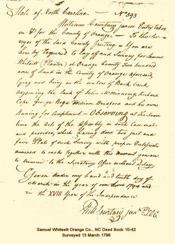
State of North Carolina No. 393 William Courtney junior Entry taken in & for the County of Orange - To the surveyor of the said county Greeting. You are hereby required to lay off and survey for Samuel Whitsett (Planter) of Orange County Two hundred acres of land in the County of Orange aforesaid, lying and being on the waters of Back Creek Adjoining the land of John McMinowey, Richard Cope, George Boyd William Bradford and his own [running] for compliment - Observing at the same time the acts of the assembly in such case made and provided, which having done two just and fair Plats of such survey with proper certificates annexed to each together with this warrant you are to transmit to the secretary's office without Delay. Given under my hand and tenth day of March in the year of our Lord 1794 and in the XVIII year of The Independence
|
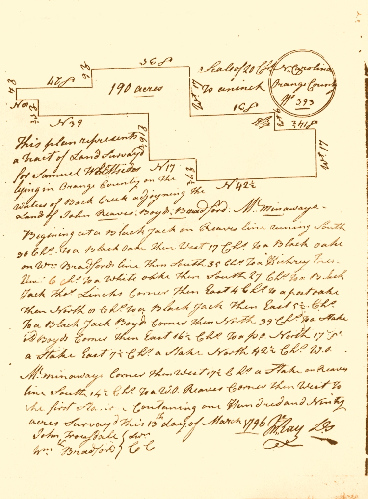
Orange County, North Carolina Deed Book 10 page 42. Surveyed on 13 March 1796 (below) |
Return
of Survey &
Cover
North
Carolina Scale of 20 Chs [chains] to an inch [sketch] This plan represents a tract of land surveyed for Samuel Whittsides lying in Orange County on the waters of Back Creek adjoyning the land of John Reaves; Boyd; Bradford; McMinaway's. Begining at a Black Jack on Reaves line running South 30 Chs. to a Black Oake then West 17 Chs. to a Black Oake on Wm. Bradford's line then South 35 Chs.to a Hickory Tree. Then 6 Chs. to a White Oake then South 27 Chs.to a Black Jack Thos. Linch's Corner then East 4 Chs. to a post oake. Then North [?] Chs.to a Black Jack then East 51/2 to a Black Jack Boyd's Corner then North 39 Chs. to a Stake [?] Boyd's Corner then East 161/2 Chs to a p.o. North 17 [Chs] a stake East 71/2 Chs.a stake North 421/2 Chs w.o. McMinoway's Corner then West 171/2 Chs.a stake on Reaves line South 141/2 Chs. to a W.O. Reaves Corner then West to the first [Black Oak] Containing one Hundred and Ninety acres survayd this 13th day of March 1796 Wm.Ray D.S. John
Trousdale [sworn C.C.] |
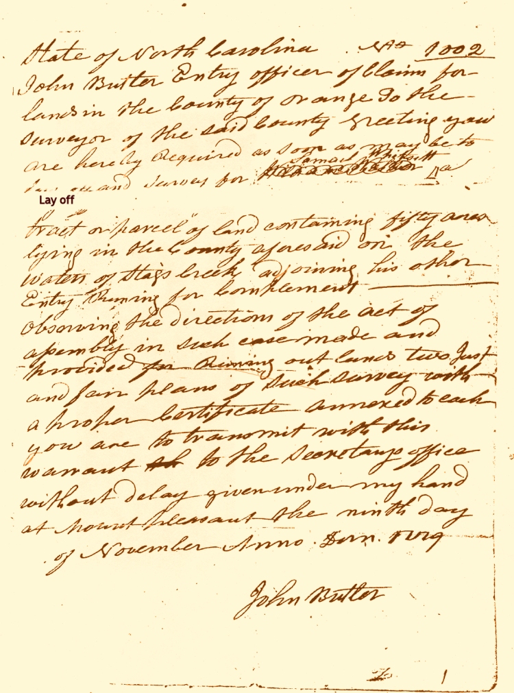
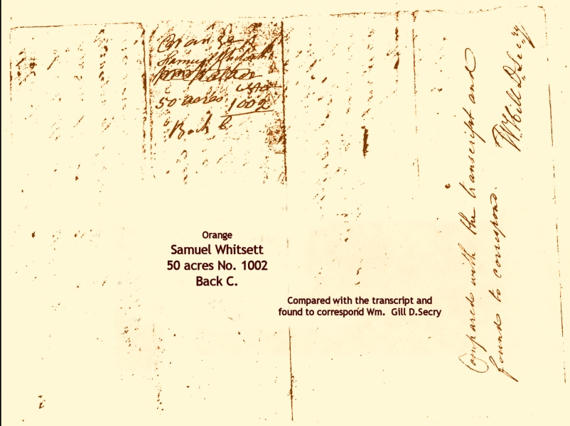
Order to Survey, Land Grant No. 1002 - 50 Acres & Cover Orange Compared
with the transcript and found to correspond
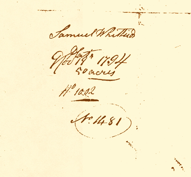
State of North Carolina No. 1002 John Butler Entry Officer of claims for lands in the County of Orange to the surveyor of the said county Greetings you are hereby required as soon as may be to lay off and survey for Samuel Whitsett a tract or parcel of land containing fifty acres laying in the County of Orange aforesaid, lying on the waters of Stags Creek Adjoining his other entry Running for compliment - Observing the directions of the acts of the assembly in such case made and provided for running out lands two just and fair Plats of such survey with proper certificates annexed to each you are to transmit with this warrant to the secretarys office without Delay given under my hand at Mount Pleasant the nineth day of November Anno Dom. 1779 [!?]
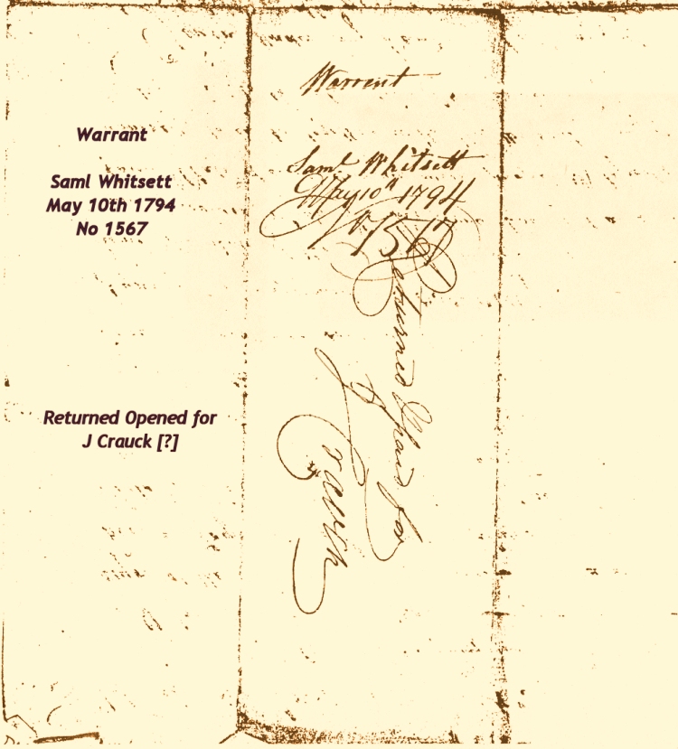
There are some interesting inconsistencies in this document. The Warrant is numbered 1002 and renumbered 1461. It states the land is on Stags Creek but the actual survey (below) and the back of the warrant says Back Creek. The date on the warrant appears to be 1779 - is is definitely NOT 1794 which is when the survey is dated. This is an unusually long time between the warrant and the survey (usually about three years). Perhaps the Revolutionary War delayed the actual survey and recording of the deed. This land is the "compliment" to Samuel Whitsett's other survey on Back Creek (above). |
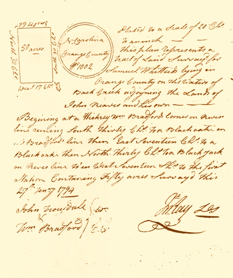
Survey January 27, 1794 & Cover Samuel
Whittsid No. 1002 No. 1481 [circled] [sketch]
North Carolina
Plated to a scale of 20 Chs. This plan represents a Tract of Land Survey'd for Samuel Whittsid lying in Orange County on the waters of Back Creek adjoyning the Lands of John Reaves and his own --- Begining at a Hickrey Wm. Bradford's Corner on Reves line runing South thirty Chs. to a Black oak on Wm. Bradford's line then East Seventeen Chs. to a Black oak then North thirty Chs. to a Black Jack on Reves line then West seventeen Chs. to the first Station Containing Fifty acres survay'd this 27th Janry 1794 John
Trousdale} swn.
Wm. Ray D.S. |
| "The
ordinary Gunter's or surveyor's chain is sixty-six
feet or four poles long, and is composed of one
hundred links, connected each to each by two rings,
and furnished with a tally mark at the end of
every ten links." ["Backsights"
Magazine published by Surveyors Historical Society].
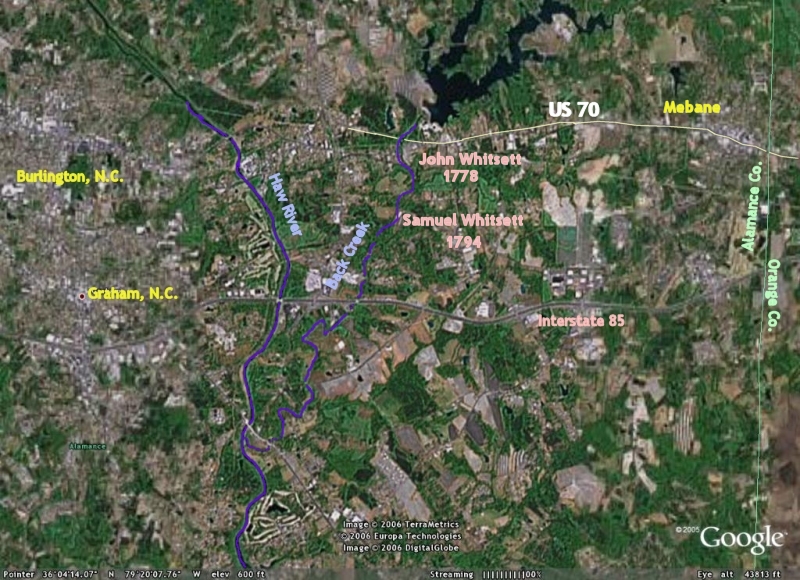
Samuel Whitsett's land ran north and south along
Back Creek, near present day Graham, Alamance
County, North Carolina for a little over a mile
and a quarter. At its widest point on the north
end of the property, including the 50 acres surveyed
in 1794 it was a little over half a mile wide.
John Whitsett's plantation was probably north
of Samuel's east of Mebane in Alamance County.
Click
HERE to see a map of the area. |
| Ronald
N. Wall Copyright © 2004. All rights reserved. Modified: 06 June 2011 |