| |
NEXT=>> |
Fort Smith, Arkansas - The Beginning
Belle Point, Fort Smith, Arkansas National Historical Site |
The Osage
came to Arkansas from their original territory in today's Missouri
and Kansas to Eastern Oklahoma and Western Arkansas replacing the
native Caddo. The Osage were a warring tribe and chased the
indigenous tribes west out of Arkansas. When the U.S. government
gave land in the area to the Cherokee and Creek to encourage them
to leave their homes in the east and move west of the Mississippi
the Osage resisted. In 1813 the Cherokee and Osage were at
war. To make matters worse, white men were invading the area reserved
for the Indians. To solve these problems General Thomas Smith
ordered a fort to built on the Arkansas. Major William Bradford
in command of Company A, Rifles Regiment landed on the sandstone
Bluff at Belle Point on Christmas day, 1817. On a hill above
the bluff, Bradford started construction of the first Fort Smith. Belle Pointe was named by
French trappers when French territory extended west from the Mississippi
from the Gulf of Mexico to the Canadian border. It was a trading
spot for the French with the native Caddo and Wichita people until Thomas
Jefferson purchased the Louisiana Territory in 1803. In 1819 naturalist
Thomas Nuttall visited the site of the new American fort being built there.
He said the view from the point was, "... more commanding and picturesque,
than any other spot of equal elevation on the banks of the Arkansas."
The area was, "...beautiful almost as the fancied Elysium ... enameled
with innumerable flowers ... serene and charming as the blissful regions
of fancy." The spot is as beautiful today as it was in Nuttall's time.
|
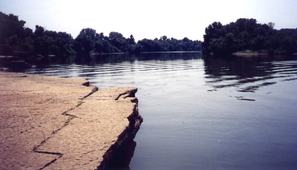 Belle Point as it looks today.
This view shows the confluence of the Poteau River (at left)
and the Arkansas River (off to right). The water level
is much higher today because of the lock and dam system put
on the Arkansas in the 1960's and 70's to make it a navigable
waterway. Originally, the stone ledge at the left would have
been a bluff about twenty feet above the river. |
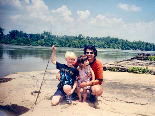
Belle Point looking down the Arkansas River towards the Garrison Avenue Bridge
(background, far right). This spot is on the Arkansas side of the
river but is actually a couple hundred yards inside Oklahoma.
The spot in the pictures is a short walk from the main buildings
in the National Historic Site and is just below the site of the
original Fort Smith.
Son-in-law Joey Madia and grandchildren Jeremy and Jolie, summer of 2001 |
|
The original site
of Fort Smith as it looks today.
The first Fort Smith was established by Maj.
William Bradford in 1817 at the confluence of the Poteau and Arkansas
Rivers. The place was known as "La Belle Pointe" by
French trappers and traders and had been used by them for trade with
the Indians when the territory was part of French Louisiana. The structure
was a small log and stone stockade named for Gen. Thomas A. Smith who
had ordered its construction. Its purpose was to ensure peace
between the Osage Indians and the newly arrived Cherokee and Creek tribes,
keep white men from trespassing in the new Indian territories and ensure
the safety of white settlers in the Arkansas territory.
|
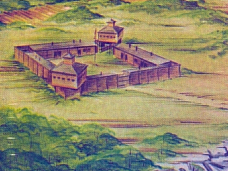
An artist's conception
of how the stockade probably appeared in its early period. Inside the
walls were quarters, shops, magazine, hospital, kitchen and storehouses.
The United States Government was in the midst
of a program to forcibly remove some Eastern tribes from the Carolinas,
Florida and Georgia to new homes in the Indian Territory created out
of the western portion of the Arkansas Territory. The first large
group were the Cherokees. The hardships these native Americans endured
is reflected in the name they gave this migration - The Trail of Tears.
|
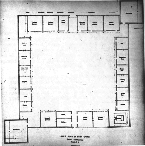
The fort was a typical
frontier fort, 132 feet square. Enclosed within a ten foot
palisade were several heavy log buildings used as quarters, shops,
hospital and storage. The fort's outer walls sat on a stone foundation.
On opposite corners were two block houses and in the middle stood
a flag pole. The fort was atop an embankment fifty feet
above the river giving it a commanding view of the Arkansas and
Poteau Rivers. As the hard work of erecting the fort progressed
rations were scarce and sickness racked the soldiers. When
the fort was completed, the men tilled the ground and began to
raise crops and livestock. The situation improved dramatically.
Some of the soldiers' wives even joined them at the fort, working
as laundresses and drawing supplies from the post commissary.
|
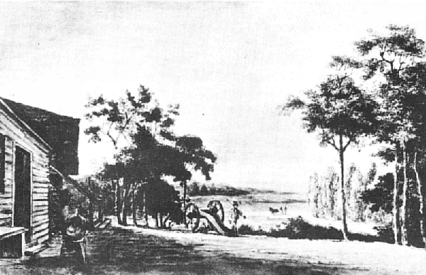
An early sketch of the original Fort
area looking towards the Arkansas River
The only real incident at the fort
occurred in April, 1820 while the commander Major Bradford was
away from the post. Four hundred Osage warriors in war paint
suddenly appeared on the north bank of the river directly across
from the fort. An alarm was sounded and the officer in charge,
Lieutenant Martin Scott peered at the warriors through his spy
glass. The chief aptly named Bad-Tempered-Buffalo signaled
that he wanted to cross with his warriors. Scott sent an
enlisted man in a boat with instructions to bring across only
the chiefs. When the Indian chiefs confronted Scott at the
fort they demanded their warriors be allowed to come across.
They also demanded access to the fort. Scott refused and
sent the chiefs back across the river.
|
The Indians began to cut down
timber to build rafts. Scott had the two six-pounder cannons rolled
into position where the Indians could see them and loaded them with canister
shot. He then sent some men in boats across the river to rescue
the family of a soldier living on the other side. The Osage warriors
were frustrated, and they vented their anger on other Indians and whites
in the area. The harassment went of for several days before the
Osage warriors disappeared.
Trouble between the Osage and
Cherokee continued until there was a threat of full-scale war between
the two tribes and their allies. Major Bradford in a daring move
told the chiefs of both tribes that if they spilled one drop of white-man's
blood, he would exterminate both tribes and would inform Washington that
there was not a single Cherokee or Osage left alive west of the Mississippi.
Congress decided to reinforce
Fort Smith and sent five companies of the 7th Infantry from Fort Scott
in Georgia to Fort Smith under the command of Colonel Mathew Arbuckle.
After a long and dreadful journey in which many of the 250 troops became
ill and died, Arbuckle arrived at Fort Smith in February 1822. When
he relieved Bradford of command, Colonel Arbuckle had only 139 surviving
men and officers. Bradford's Rifles Regiment was disbanded and the
men assigned to Arbuckle's 7th Infantry.
Arbuckle sent headquarters
a glowing report on Major Bradford and the status of the Fort, and well
he should have. Bradford for four years deep in the midst of Indian territory
with warring tribes on all sides had maintained peace, constructed a strong
and valuable fort and kept his men disciplined and fit. Testimony
to his ability as a commander and peace keeper was the fact that not one
soldier under his command died from enemy action, or even fired a single
shot at an Indian.
In July 1822 Arbuckle convened
a Grand Council between the leaders of the Osage and Cherokee tribes.
After nearly two weeks, a treaty was finally signed and the two tribes
were at relative peace with each other. However, hostilities continued
further west and when they once again escalated to the point of war, Arbuckle
advised Washington that a fort should be established on the Arkansas and
Verdigris, about eighty miles above Fort Smith (near present day Muskogee)
where his troops could be more effective.
In March, 1825 General Winfield
Scott ordered Arbuckle to remove his regiment from Fort Smith and establish
the new fort. No one was to be left at Fort Smith. By the
end of April 1825 the first Fort Smith was abandoned and what was to become
Fort Gibson was founded.
|
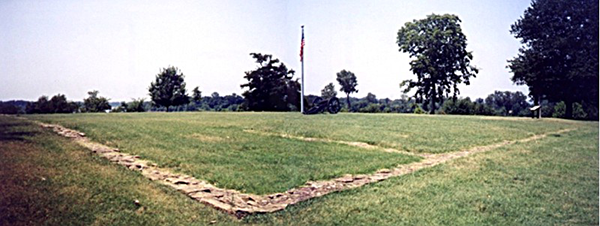
All that
remains of the original fort is the stone foundation. This view
is from the side nearest the river looking back towards the town
of Fort Smith. |
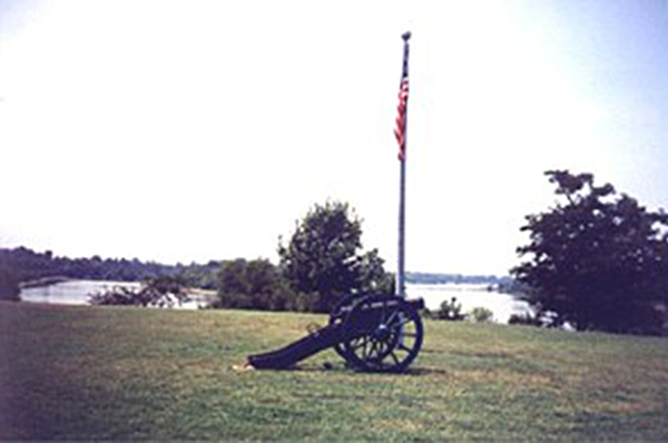
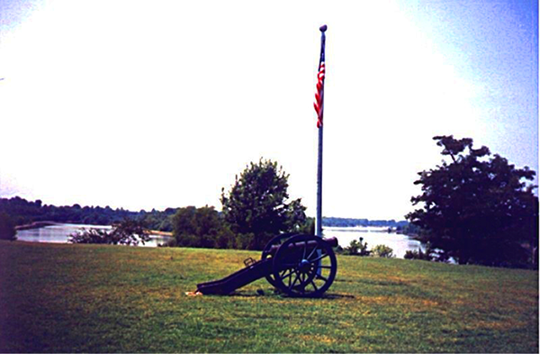
A six-pound
cannon of the 1820's sits guard over the site of the original Fort
Smith. This view is from the opposite side of the view on
the left. The Poteau River can be seen on the left in the photo
and the Arkansas River on the right.
|
| |
NEXT=>> |